
ABOUT THE PROJECT
Project Update:
Brooks-Hopmere Future Report
The draft Brooks Hopmere Future Report ready for review.
The project team has prepared a draft Brooks-Hopmere Community (BHC) Future report, outlining future recommendations for the area and steps to implement this future. Use the link below to view or download the report. It builds on earlier planning efforts, including evaluation of several different scenarios for the future of the area. It also reflects comments and priorities from community members and stakeholders provided at our most recent community meeting (held on March 2), as well as through an earlier online survey, interviews, meetings with community stakeholders, and comments provided via phone and email.
The full report can be found here (link).
Please tell complete a quick 10 minutes survey (link) to tell us your thoughts on the Future Report. The survey will close on Thursday, June 25th.
What is the Brooks-Hopmere Community Plan?
The Brooks-Hopmere Community is an unincorporated community consisting of homes, commercial and industrial businesses, and public facilities and uses. Marion County is working with a team of consultants to conduct the first phase of a Brooks-Hopmere Community Plan update, which will assess the existing conditions of the community and establish a vision for the future. The future vision will be based on development and evaluation of several potential future scenarios which will be based on guidance and input from community residents, business and property owners. The original Brooks-Hopmere Community Plan, adopted in 2000, can be found at this link.
Project Objectives
Marion County is exploring existing conditions, opportunities, and a vision for the future of the Brooks-Hopmere unincorporated area, along with steps that set the County and the community on a pathway towards achieving that vision.
The County and its consultants will work closely with local residents, businesses, property owners, and other local organizations to understand existing conditions and future visions coupled.
The County also will conduct extensive research on land-use, transportation, and infrastructure needs associated with current and desired future conditions. Exploration of development scenarios driven by community feedback will be used to determine a proposed future vision.
Purpose
To gain an understanding of…
Opportunities
1) How to capitalize on the resources in the Brooks-Hopmere community to create future economic development opportunities and meet the needs of community stakeholders.
2) How to ensure that the County and community realize opportunities for development in the Hwy 99 corridor and help address a lack of developable land directly adjacent to the I-5 corridor and its interchanges.
Policy
What types of plans and policy revisions are necessary to prepare for anticipated future planning efforts for the I -5 interchange and surrounding areas?
Informed by stakeholders
Throughout the project community stakeholders will have opportunities to inform the planning process and its outcomes.
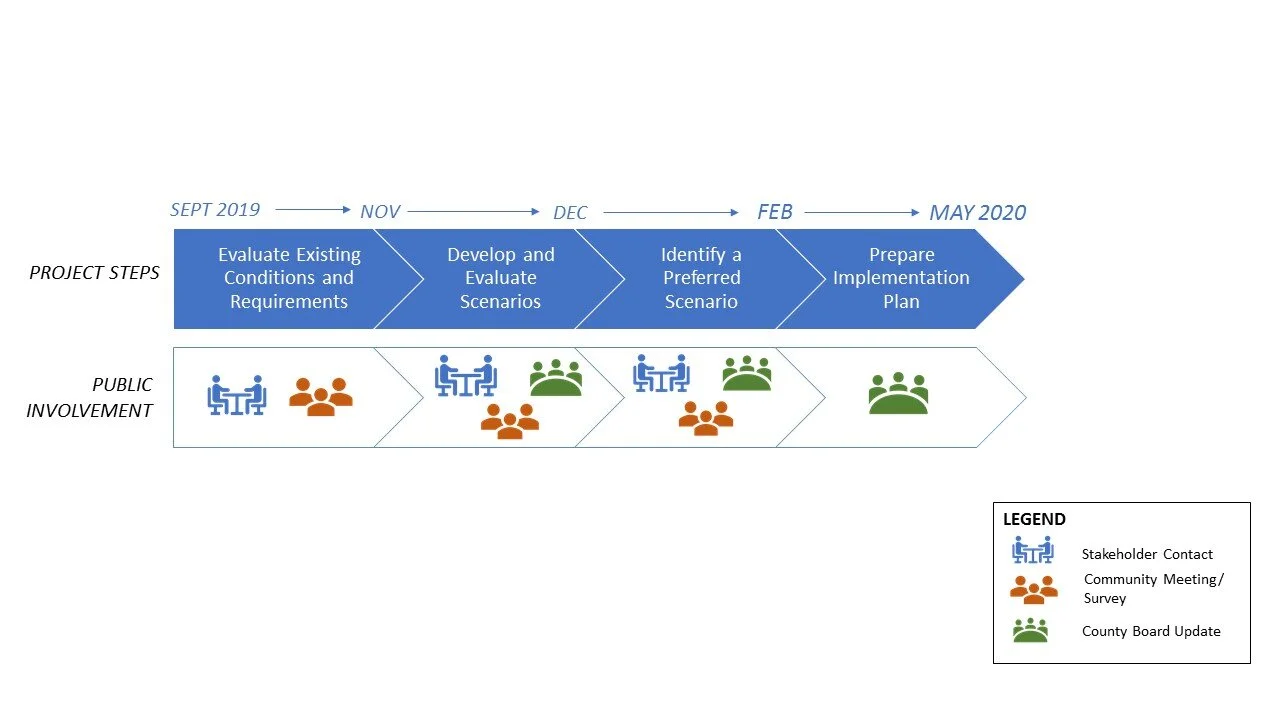
Project Schedule
The planning process for this Phase 1 effort began in August 2019 and will conclude in late Spring, 2020. A proposed plan and budget for conducting a subsequent phase of the planning effort will be completed by April, 2020.
Overview:
Step 1 - Evaluating Existing Conditions and Requirements
September - November 2019
Public Involvement includes stakeholder contact and community survey.
Step 2 - Develop and Evaluate Scenarios
November - December 2019
Public involvement includes stakeholder contact, community meeting, and County Board update.
Step 3 - Identify Preferred Scenario
December 2019 - February 2020
Public involvement includes stakeholder contact, community meeting, and County Board update.
Step 4 - Prepare Implementation Plan
February - May 2020
Public involvement includes County Board update.
Project Area
As shown on the accompanying map, the project includes a primary study area which will the focus of the majority of analysis and recommendations along with a larger secondary area which will be included in community outreach efforts.
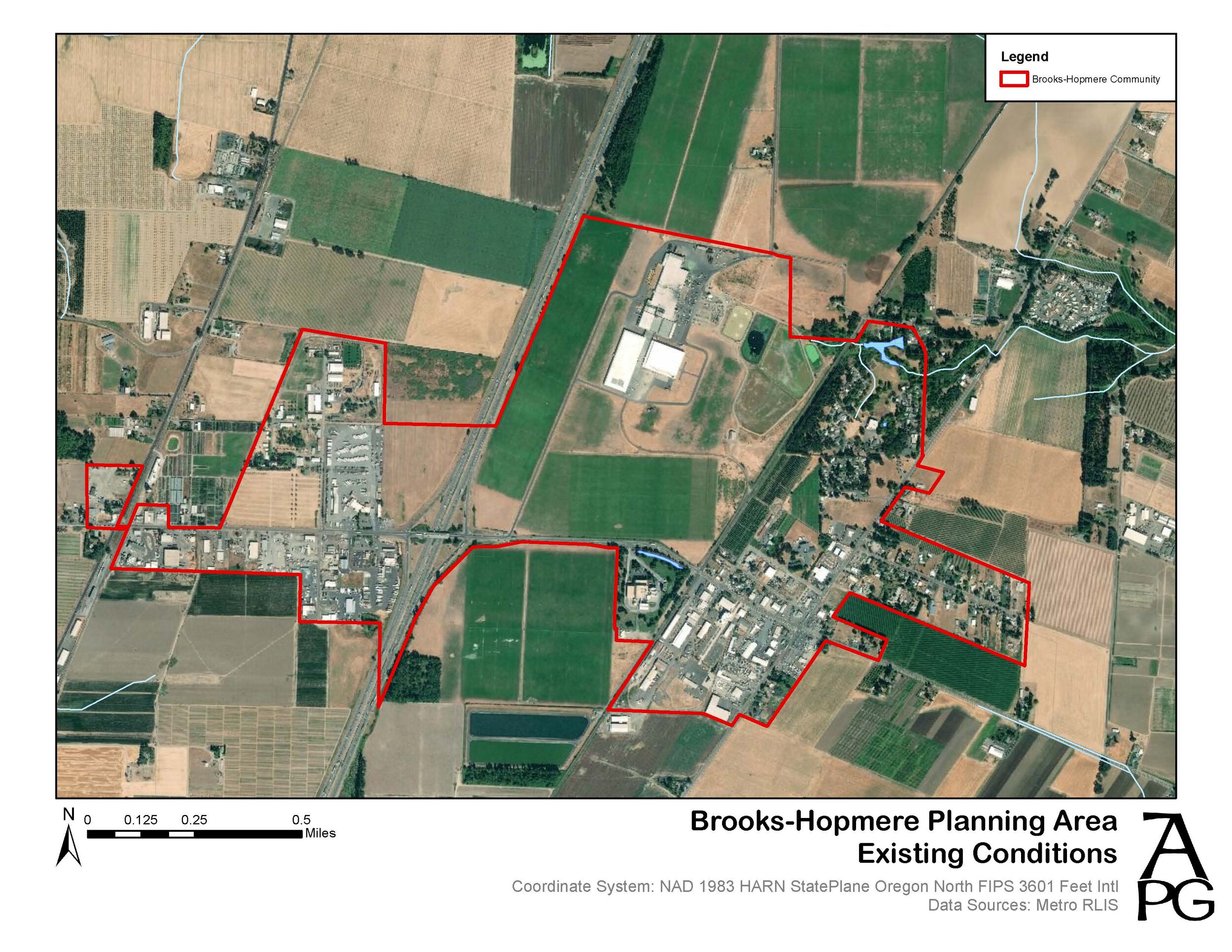
The map shows the Brooks-Hopmere Community Plan Boundary. The community is generally defined by River Rd. NE to the west and 57th Avenue to the east, inclduing the Brooklake/Interstate-5 interchange.